Site guide
Visiting the Étretat Cliffs: Arches, Walks and Practical Tips
Quick answer
Give Étretat half a day: walk up the Falaise d'Aval for the arch and the 51-meter Aiguille, then cross the beach to the chapel on the Falaise d'Amont. Parking is paid all year. It's about 36 minutes by road from Le Havre and 202 km (126 miles) from Paris, or a 13-hour day tour from $133 / €119.
| Fact | Detail |
|---|---|
| From Paris | About 202 km (126 miles), roughly 2 h 35 without traffic |
| From Le Havre | 29 km (18 miles) from the train station, about 36 min; buses Nomad 509 and LiA 13 and 21 |
| Parking | Paid all year, 9 a.m. to 7 p.m.: €7.50 (about $8) for 5 hours or €15 (about $17) for the day in the outer car parks |
| The Aiguille | A 51-meter (167-foot) needle of rock off the Porte d'Aval arch |
| Safety rules | No walking at the foot of the cliffs; stay at least 5 meters back from the edge on top |
Étretat is a small seaside town on the Alabaster Coast, north of Le Havre, and it's famous for one view: a white chalk cliff ending in a huge arch, with a needle of rock standing in the sea beside it. That's the Falaise d'Aval. Across the pebble beach, the Falaise d'Amont has its own arch and a sailors' chapel on top. Seeing both well means two short, steep walks, an eye on the tide, and a plan for parking.
Everything practical on this page, from parking rates to bus lines and the safety by-law, was checked against the Le Havre Étretat tourist office's site in November 2026. Distances are from OpenStreetMap routing.
Climb the Falaise d'Aval toward sunset. From the top, the Aiguille and the arch fall into shadow while the sea below turns gold.
The cliffs at a glance
Stand on the seafront facing the sea, and the two cliffs frame the beach.
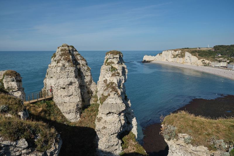
The Falaise d'Aval (left, to the west). The one most people come for. Its end is the Porte d'Aval, an arch the tourist office describes as carved by the waves, and just off it stands the Aiguille, a needle of chalk 51 meters (167 feet) high. Maurice Leblanc made it the hiding place of a royal treasure in his Arsène Lupin novel L'Aiguille creuse; his house in town, Le Clos Lupin, is now a visitor site.
The Manneporte. Farther west along the same cliff, beyond the Porte d'Aval, is an even bigger arch, the Manneporte. Guy de Maupassant claimed a ship could sail through it with all its sails up.
The Falaise d'Amont (right, to the east). Its arch, the Porte d'Amont, is the one Maupassant compared to an elephant dipping its trunk in the sea. On top stands the Chapelle Notre-Dame-de-la-Garde, a sailors' chapel first blessed in 1856, destroyed by the German occupiers in 1942 and rebuilt in 1950, according to the tourist office. The Jardins d'Étretat, a contemporary topiary garden that won the European Garden Award in 2019, are on the same cliff.
The cliffs rise to nearly 90 meters, and painters came early: the tourist office credits Eugène Isabey as the first to paint Étretat, in 1820, followed by Turner, Boudin, Monet and many others.
The two cliff-top walks
Both walks start from the seafront promenade, and both are short. What makes them work is the climb, not the distance.

Falaise d'Aval. On OpenStreetMap's walking routes, the top of the cliff above the Porte d'Aval is about 1 km (0.6 mile) from the tourist office on Place Maurice Guillard. From the top you look down on the arch and the Aiguille, and the path continues west toward the Manneporte. This is the view on the postcards.
Falaise d'Amont. The chapel is about 600 meters (0.4 mile) from the tourist office on the same walking routes, again uphill. From the top you get the whole bay, with the Falaise d'Aval and its arch across the water.
My suggestion: do the Amont side first while you're fresh, come down for a coffee on the seafront, then climb the Aval side. Allow three to four hours for both, with stops. If you want to keep walking, the coast path here is part of the GR21, the long-distance trail from Le Havre to Le Tréport.
Two rules from the town's by-law apply on top: walking on the high plateaus of both cliffs is banned within 5 meters of the edge, and you should stay on the marked paths. The tourist office is blunt about why: the cliffs are always at risk of rockfalls.
If you'd like a guide, Natterra runs naturalist walks on the cliffs for small groups of 2 to 10 people, over 2 to 3 km, according to the tourist office.
Tides, the beach and safety
The beach is pebbles, not sand. The tourist office explains that the pebbles protect the town, which is built below sea level, from storms, so taking them is forbidden and fined.
The bigger risk is the tide. In the tourist office's words, many visitors get trapped between two cliffs by the rising tide. The town's by-law sets the rules:
- Walking at the foot of the cliffs is forbidden.
- The tunnel and cave called the Trou à l'Homme, the rocks above it and the spots known as the Chambre des Demoiselles and the Descente au Chaudron are closed to the public.
- The beaches along the town's coastline are off limits, except the stretch next to the promenade.
- Breaking these rules can bring a fine, and the fire service bills for non-emergency call-outs.
So treat the beach in front of town as the place to be, and the cliffs as something to see from the beach or from above. If you're going down to the water at all, check the tide times first; SHOM, the French navy's hydrographic service, publishes them online.
You can swim off the beach; follow the instructions at the first-aid post. To see the arches from the water, the Voiles et Galets club rents kayaks and paddleboards from Easter to November.
Parking and crowds
Étretat has few parking spaces for the number of visitors, and parking is paid all year, including weekends and holidays, from 9 a.m. to 7 p.m. The rates below have applied since January 1, 2025:

| Zone | Car parks | Price |
|---|---|---|
| Orange (outer car parks) | Grand Val, Fréfossé, the old station (Parking de la Gare), Route de Criquetot | €7.50 (about $8) for 5 hours, €15 (about $17) for 10 hours, €30 for a 3-day weekend |
| Red (town center) | Place de la Mairie, Place du Général de Gaulle, Place du Marché | €3 (about $3) an hour, up to €15 (about $17) for 5 hours |
Stay past 5 hours in the center or 10 hours in the outer car parks and the charge jumps to €50 (€35 at the reduced rate). Use the orange car parks for a half-day visit: the price is the same as two and a half hours in the center. Don't leave the car on the verge of the Route de Criquetot at the entrance to Étretat: the tourist office warns that obstructive parking there gets ticketed.
Thirteen towns around the cliffs are working with the local authorities on the "Grand Site de France" label, which includes rethinking parking and visitor flows. If you want to see the Aiguille de Belval, a needle farther east along the coast, the neighboring village of Bénouville has set up temporary parking with a walkway.
On crowds, the simple answer is timing. If you arrive before 10 a.m., you'll have a better chance of a space in the orange car parks and quieter cliff paths.
Getting there
From Le Havre. Étretat is 29 km (18 miles), about 36 minutes by road, from Le Havre train station, and about 40 minutes from the cruise terminal. Without a car, the tourist office lists the Nomad line 509 coach from Le Havre station and the LiA city lines 13 and 21. If you're arriving by ship, my Le Havre cruise port guide compares shore excursions and car rental at the terminal.
From Paris by car. About 202 km (126 miles), roughly 2 hours 35 minutes without traffic, by the A13. The A13 Saint-Cloud tunnel is closed in the Paris-to-Normandy direction from November 16, 2026 to August 31, 2027, according to the Préfecture d'Île-de-France, so plan the way out of Paris. My Paris to Normandy guide covers the detour and the tolls.
From Paris by train and bus. Take a train from Paris Saint-Lazare to Bréauté-Beuzeville, then the Nomad line 504 coach to the center of Étretat: that's the route the tourist office gives. Check the coach times before you buy the train ticket.
From Paris on a day tour. The tour I found that pairs Étretat with Honfleur is run by Dream City Bus Tours. It leaves from Avenue de Wagram by the Arc de Triomphe, lasts about 13 hours in a coach and gives 2 hours in Honfleur after the stop in Étretat. Prices and ratings as of November 15, 2026:
| Platform | Price | Rating | Book |
|---|---|---|---|
| Viator | from $133 / €119 per person | 4.6 from 11 reviews | Check datesvia Viator |
| GetYourGuide | from $167 / €149 per person | 4.7 from 306 reviews | Check datesvia GetYourGuide |
It's the same operator on both. Viator is cheaper on the day I checked; GetYourGuide has far more reviews to read before you book.
From Rouen, Étretat is 87 km (54 miles), about 1 hour 15 minutes by road. My Rouen guide covers the city.
Combining Étretat with Honfleur
The two make a natural pair: 45 km (28 miles) and about 45 minutes apart by road, over the Pont de Normandie. With a car, do Étretat first, while the car parks still have space and the cliff paths are quiet, and drive to Honfleur for a late lunch and the old harbor in the afternoon. My Honfleur guide covers what to see there and where to park.

I'd keep the day to these two. Add a third stop and you'll rush the cliffs, which are the reason to come.
If you have a second day and a car, head the other way instead: north along the cliffs to Yport, Fécamp, Veules-les-Roses and Dieppe. My Alabaster Coast guide covers that drive stop by stop.
Where to stay
Étretat is a small town, so rooms are limited. If you want the cliffs at sunrise or sunset without a drive, it's worth staying in town. Otherwise, Le Havre, 36 minutes away, and Honfleur, 45 minutes, both have more hotels, and Honfleur works as a base for the whole coast. My where to stay in Normandy guide compares the bases.
More of the Étretat cliffs from my visits
Étretat 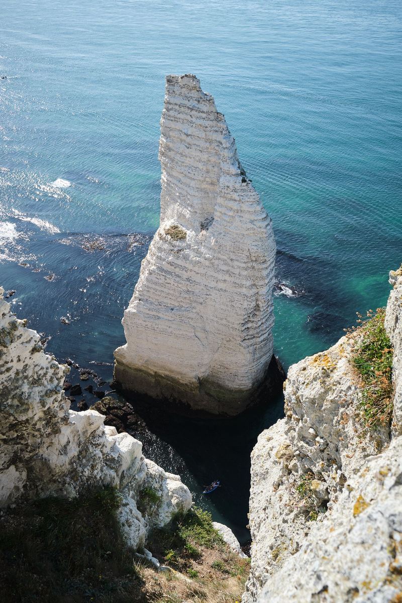
Étretat 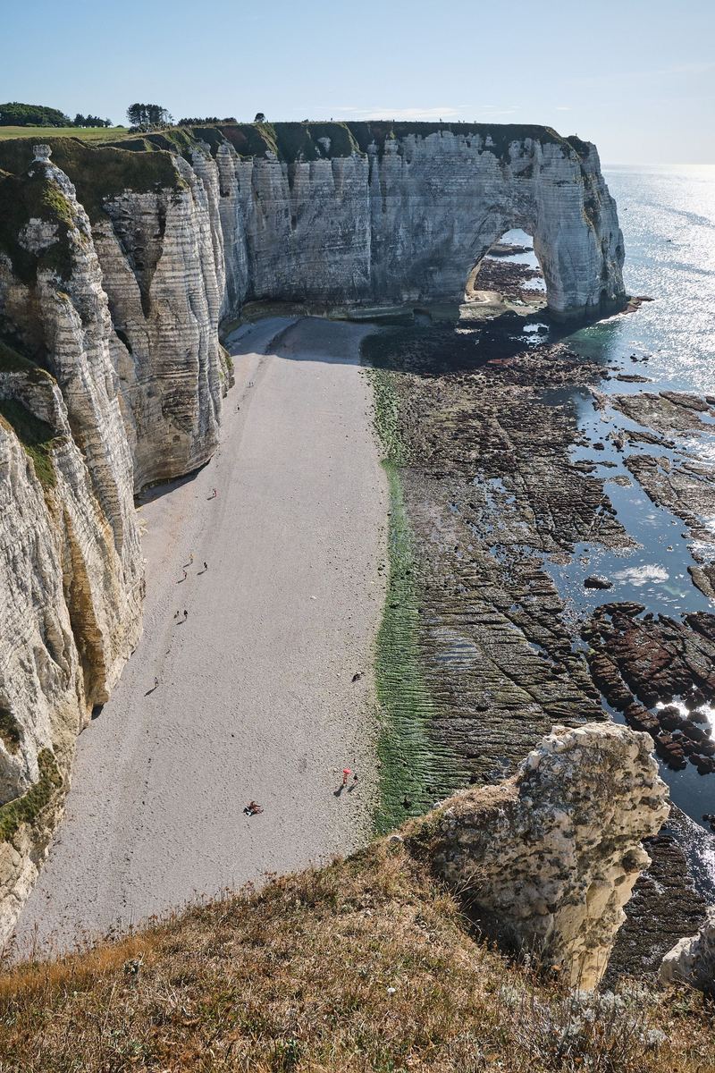
Étretat 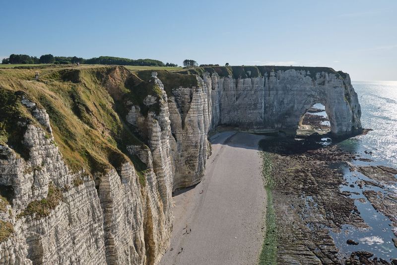
Étretat


Frequently asked questions
Is Étretat worth visiting?
Yes, if you like coastal scenery and don't mind a climb. The two cliffs on either side of the beach, with their natural arches and the Aiguille needle, are what the town is known for, and painters from Isabey and Turner to Boudin and Monet came here to paint them. The town itself is small, so plan it as a half day or pair it with Honfleur.
How long do you need at the Étretat cliffs?
Three to four hours covers both cliff tops and a walk along the seafront. On OpenStreetMap's walking routes, the top of the Falaise d'Aval is about 1 km from the tourist office and the chapel on the Falaise d'Amont about 600 meters, but both paths climb. Day tours from Paris that also stop in Honfleur leave you less time than that.
Can you reach Étretat without a car?
Yes. From Le Havre, the tourist office lists the Nomad line 509 bus from the train station and the LiA lines 13 and 21. From Paris, take the train from Saint-Lazare to Bréauté-Beuzeville and the Nomad line 504 bus to the village. Or join a day tour from Paris: Dream City Bus Tours' Étretat and Honfleur trip is from $133 / €119 on Viator.
Étretat or Honfleur if you only have time for one?
Étretat for landscape and walking, Honfleur for an old harbor town, its wooden church and museums. They're 45 km (28 miles) apart, about 45 minutes by road over the Pont de Normandie, so with a car you can do both in a day: the cliffs in the morning, Honfleur in the afternoon.
Sources (16)
- Le Havre Étretat Normandie Tourisme: the cliffs of Étretat
- Le Havre Étretat Normandie Tourisme: discover Étretat (painters, history, sights)
- Le Havre Étretat Normandie Tourisme: the beach of Étretat (tides, pebbles, safety)
- Le Havre Étretat Normandie Tourisme: the gardens of Étretat
- Le Havre Étretat Normandie Tourisme: parking and getting around in Étretat (rates from January 1, 2025, by-law)
- Le Havre Étretat Normandie Tourisme: coming to Étretat (bus and train)
- Le Havre Étretat Normandie Tourisme: Chapelle Notre-Dame-de-la-Garde
- Le Havre Étretat Normandie Tourisme: nature walk along the cliffs (Natterra)
- Nomad (Normandy region coaches): line 509, Le Havre to Étretat and Fécamp
- Nomad: line 504, Bréauté-Beuzeville station to Étretat
- SHOM: official French tide predictions
- Préfecture d'Île-de-France: A13 Saint-Cloud tunnel closure from November 16, 2026
- Viator: Dream City Bus Tours, From Paris: a day tour to the cliffs of Étretat and Honfleur (checked November 15, 2026)
- GetYourGuide: Dream City Bus Tours, Étretat Cliffs & Honfleur Port Full-Day Trip from Paris (checked November 15, 2026)
- OSRM (OpenStreetMap routing): driving and walking distances
- Banque de France: EUR/USD reference rate, November 10, 2026
Keep planning
Related guides