Site guide
Visiting Pointe du Hoc: The Ranger Monument, Craters and What Is Open Now
Quick answer
Pointe du Hoc is open and free, but it's a building site until mid-2027. Visitors can only use the west path, the visitor center is closed, and the granite Ranger Monument was lifted off its bunker in June 2026 for storage. You can still walk among the bomb craters. Allow 45 minutes to an hour.
| Fact | Detail |
|---|---|
| Admission | Free, no booking needed |
| Hours | 9 a.m. to 5 p.m. daily; from October to March, closed 12:30 to 1:30 p.m. |
| Works | Until mid-2027; west path only; visitor center closed since March 9, 2026 |
| Ranger Monument | Removed June 17, 2026, to be reinstalled at the new Memorial Plaza |
| From Bayeux | 30 km (19 miles), about 33 minutes by car |
| UNESCO | Part of the D-Day landing beaches World Heritage Site since July 26, 2026 |
Pointe du Hoc is the headland between Utah and Omaha beaches where US Army Rangers climbed the cliffs on the morning of June 6, 1944, to knock out a German coastal battery. The ground on top is still churned into bomb craters, with wrecked concrete casemates between them. It's run by the American Battle Monuments Commission (ABMC), the same US agency that runs the Normandy American Cemetery, and since July 26, 2026, it has been part of the UNESCO World Heritage Site of the D-Day landing beaches.
If you're going before mid-2027, though, the most useful thing to know is what you won't see. ABMC is in the middle of a major restoration, and the site you'll find is smaller and quieter than the one in the photos. Everything below was checked against ABMC's own pages on November 15, 2026.
What is open during the 2026-2027 works
ABMC broke ground on February 17, 2026. Its notice says the project will last until mid-2027, and its FAQ adds that the work "will take over 18 months" from February 2026, so treat mid-2027 as a target rather than a promise. Here is where things stand, according to ABMC's restoration page:
| Status | |
|---|---|
| The site | Open daily, free |
| Historic area | West path only; parts closed since mid-May 2026, including pathways and bunkers |
| Visitor center | Closed since March 9, 2026; staff at a welcome point near the provisional parking lot |
| Main parking lot (P1) | Closed, expected until early 2027 |
| Other parking | Alternative lots, which ABMC says will be limited |
| Restrooms | Next to the parking areas |
| Ranger Monument | Removed on June 17, 2026, and in storage |
| Wheelchair access | Not possible during the works |
ABMC's phase map for mid-May to mid-October 2026 shows the whole east side fenced off: pathways, bunkers, the ceremonial plaza, the bocage overlook and the crater bridges. The open path runs up the west side to the tip of the point. ABMC hasn't published a newer map, and its page still says access is along the west path only, so expect the same layout and follow the signs on the day.
The Ranger Monument isn't on the point right now. On June 17, 2026, ABMC lifted the granite dagger and its two side elements, which it calls "the books," off the German bunker at the end of the point. ABMC says the dagger was no longer safe there and will be stored until it can go up at the new Memorial Plaza, which the project is building as "the heart of the site." If the monument is the reason you're going, wait for the reopening.
What the project is for: new paths that keep visitors safe as the cliffs erode, plus a renovated parking lot, welcome plaza, visitor center and Memorial Plaza. Erosion isn't new here. In March 2023, landslides closed the path to the observation bunker, and a large landslide in November 2023 closed the platform on the bunker known as the Flakstellung or Rudder bunker, according to ABMC.
The Rangers' assault on June 6, 1944
The Army's own account, Small Unit Actions (published by the War Department's Historical Division in 1946), is the best source for what happened here, and the facts below come from it and from ABMC.

The target. The Germans had built a position on the point for six French-made 155 mm guns, which could reach both Utah and Omaha beaches. The cliffs are 85 to 100 feet high, sheer or overhanging, above a narrow beach with no cover.
The plan. Three companies of the 2nd Ranger Battalion, D, E and F, about 225 men under Lieutenant Colonel James E. Rudder, were to land at the foot of the cliffs at H-Hour, 6:30 a.m., and climb them. Their landing craft carried rockets that fired grapnels trailing ropes and rope ladders to the cliff top, plus extension ladders. Lieutenant Colonel Max Schneider's 5th Ranger Battalion and the rest of the 2nd waited offshore to follow if the assault succeeded.
The landing. Rough seas swamped one of the Rangers' landing craft and sank a supply craft on the way in, and the guide boat headed for the wrong headland, Pointe de la Percée, three miles to the east. Rudder turned the column back, but the Rangers touched down at about 7:10 a.m., 40 minutes late. With no success signal in time, Schneider's force landed at Omaha Beach instead, as the plan provided. Under fire from above and with the destroyer USS Satterlee firing on the cliff top, the Rangers were climbing within minutes. Within 30 minutes of touchdown, almost the whole assault force was on top.
The guns. The emplacements were empty: the Germans had moved the guns inland before the attack. At about 9 a.m., a two-man patrol of First Sergeant Leonard Lomell and Staff Sergeant Jack Kuhn found five of them about 250 yards down a hedgerowed lane south of the coastal road, camouflaged, ready to fire and unguarded. Lomell put thermite grenades in two and smashed the sights of a third, and a Company E patrol finished the job.
The cost. The Rangers then held the point and the road against counterattacks for two days. By June 7 Rudder had about 90 men still able to fight. The relief force from Omaha reached them on the morning of June 8.
What to see: the craters, the casemates and the monument
The craters. The bombing and naval shelling before the landing left the top of the point a field of overlapping craters. ABMC describes the area as remaining "much as the Rangers left it." Even during the works, the west path takes you through them.
The casemates and gun positions. Concrete gun casemates, the remains of open gun pits and other bunkers sit among the craters, several of them broken open by the bombardment. Many are behind fences: ABMC studied the structures, found several unsafe and fenced them off, and the east side is inside the construction zone until the works end.
The Ranger Monument. In normal times, a granite pylon shaped like a dagger stands on a German bunker at the tip of the point, with tablets in French and English at its base. It was erected by the French to honor the 2nd Ranger Battalion and handed over to ABMC on January 11, 1979. As described above, it's in storage until the new Memorial Plaza is finished.
The cliffs. From the end of the point you can look straight down to the beach the Rangers crossed and along the coast toward Omaha. Stay on the marked path: ABMC asks every visitor to, and the cliff edge here has been collapsing.
Walking among the craters with the wind coming off the Channel, then looking down the cliff the Rangers climbed, changes the scale of everything you've read about that morning.
Practical info: hours, parking, accessibility and safety
| Book | |
|---|---|
| Hours | 9 a.m. to 5 p.m. every day |
| Winter break | October 1 to March 31: closed 12:30 to 1:30 p.m. |
| Admission | Free, no booking |
| Address | 14450 Cricqueville-en-Bessin |
| Parking | Provisional lots during the works; follow the signs |
| Restrooms | Next to the parking areas |
| Accessibility | Not wheelchair accessible until the works are complete |
| Animals | Service dogs only |
| Drones | Need an ABMC film permit |
| Contact | +33 (0)2 31 51 62 00, NormandyVisits@abmc.gov |
Plan around the midday break in winter. From October to March, ABMC lists a closure from 12:30 to 1:30 p.m. If you're driving from the cemetery in the late morning, come here first or after lunch.

Wear real shoes. The ground between craters is uneven, often muddy, and exposed to the wind off the Channel.
Guides on site. While the works go on, ABMC has no fixed tours here. Its guides walk the site and answer questions, and ABMC announces seasonal talks on its social media and on signs at the site.
Behavior. ABMC asks for "the utmost respect and solemnity" at all its sites. Personal photos are fine; wedding shoots, TikTok videos and influencer content are not.
How long to spend and how to combine it
With only the west path open, 45 minutes to an hour is enough. Tours list between 20 minutes and an hour.
Pointe du Hoc sits in the middle of the American sector, so it fits naturally between the two beaches. Driving times from OpenStreetMap routing:
| From Pointe du Hoc to | Distance | Time |
|---|---|---|
| Grandcamp-Maisy | 4.5 km (2.8 mi) | 6 min |
| Omaha Beach (Les Braves, Saint-Laurent-sur-Mer) | 10 km (6.3 mi) | 13 min |
| Normandy American Cemetery | 14 km (8.6 mi) | 19 min |
| Bayeux | 30 km (19 mi) | 33 min |
| Utah Beach Museum | 40 km (25 mi) | 40 min |
A simple half day from Bayeux: the cemetery first (last admission is 4:30 p.m.), then Omaha Beach, then Pointe du Hoc, with lunch in Grandcamp-Maisy, the nearest town. For a full day, continue west to Utah Beach. The self-guided driving route and my D-Day beaches guide put it all in order.
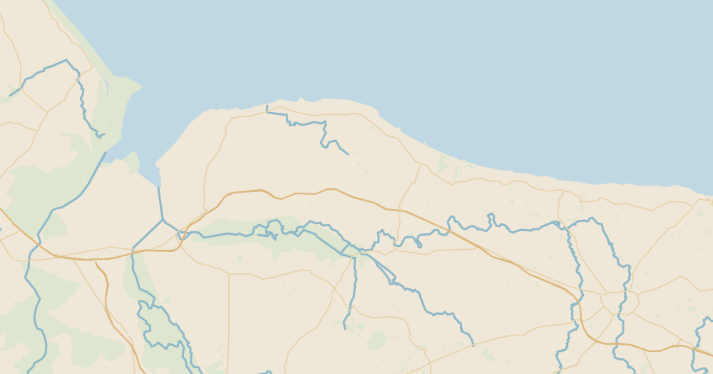
- 1Bayeux · 30 km (19 mi), about 33 min
- 2Pointe du Hoc · West path only until mid-2027
- 3Omaha Beach (Les Braves, Saint-Laurent-sur-Mer) · 10 km (6 mi), about 13 min
- 4Normandy American Cemetery · 14 km (8.6 mi), about 19 min; last admission 4:30 p.m.
- 5Grandcamp-Maisy · 4.5 km (2.8 mi), about 6 min
- 6Utah Beach Museum · 40 km (25 mi), about 40 min
Map data © OpenStreetMap contributors (ODbL)
Tours that stop at Pointe du Hoc
Most American-sector tours still list Pointe du Hoc, works or not. Prices from Viator unless noted, as of November 2026:

| Tour | Starts from | Minutes at Pointe du Hoc | Price from |
|---|---|---|---|
| Bayeux Shuttle, Omaha afternoon tour | Bayeux | 60 | $99 / €88 |
| Normandy Sightseeing Tour, afternoon half day | Bayeux | 60 | $103 / €92 |
| Normandy Sightseeing Tour, US full day | Bayeux | 60 | $149 / €133 |
| GoldBeachCompany, American beaches full day | Bayeux | 60 | $157 / €140 |
| Ophorus, American D-Day sites full day (GetYourGuide) | Bayeux | 60 | $213 / €190 |
| HQ Company Tour, American beaches and US Airborne (GetYourGuide) | Bayeux | 50 | $157 / €140 |
| Bayeux Shuttle, American D-Day Experience full day | Bayeux | 40 | $167 / €149 |
| Ophorus, U.S. D-Day sites half day | Bayeux | 30 | $123 / €110 |
| City Wonders, D-Day sites and cemetery with lunch | Paris | 60 | $118 / €105 |
| The Tour Guy, D-Day beaches with lunch | Paris | 20 | $93 / €83 (sale price until December 4, 2026) |
Dollars at $1.1214 per euro (November 10, 2026), rounded. The minutes are the operators' figures. Ophorus's full-day listing warns that, because of the works, the Pointe du Hoc stop may be swapped for another site such as the Longues-sur-Mer battery; the other listings I checked on November 15 still show it. GoldBeachCompany's half day doesn't go to Pointe du Hoc at all.
For an afternoon from Bayeux, Bayeux Shuttle gives Pointe du Hoc a full hour alongside the cemetery and Omaha.
Check dates for Bayeux Shuttle's afternoon tour on Viatorvia Viator
For the whole American sector in a group of eight, GoldBeachCompany's full day lists an hour here and an hour each at Omaha, the cemetery, the Utah Beach Museum and Sainte-Mère-Église.
Check dates for GoldBeachCompany's full day on Viatorvia Viator
From Paris, City Wonders' day trip lists an hour at Pointe du Hoc and includes a guided visit of the battlefield, in a coach of up to 50.
Check dates for City Wonders from Paris on Viatorvia Viator
Group sizes and the rest of each itinerary are compared on D-Day tours from Bayeux and D-Day tours from Paris.
Driving there
From Bayeux: about 30 km (19 miles), 33 minutes. ABMC's directions: the N13 toward Cherbourg, the D517 into Saint-Laurent-sur-Mer, then left on the D514 toward Pointe du Hoc. At the roundabout about 6 miles (10 km) west of Saint-Laurent, a sign reads "La Pointe du Hoc." During the works, follow the signs to the provisional parking lot.
From Paris: the A13 to Caen, then the N13. Bayeux is 263 km (163 miles) from Paris. Note that the A13 Saint-Cloud tunnel is closed toward Normandy from November 16, 2026, to August 31, 2027, according to the Préfecture d'Île-de-France.
Without a car: trains run from Paris Saint-Lazare to Bayeux, about three hours according to ABMC, and from there it's a taxi or a tour.
For a car, Bayeux is the closest rental base to the American sector. More in car rental in Bayeux or Caen.
Compare rental cars in Bayeux on Discover Carsvia Discover Cars
Frequently asked questions
Is Pointe du Hoc open?
Yes, every day, but only in part. ABMC began a restoration project in February 2026 that is due to last until mid-2027. The visitor center has been closed since March 9, 2026, parts of the site, including pathways and bunkers, have been closed since mid-May 2026, and access is along the west path only. The main parking lot (P1) is closed until early 2027.
Is Pointe du Hoc free?
Yes. ABMC, the US government agency that runs the site, lists admission as free with no advance booking. The 2027 pre-registration ABMC is planning applies to the Normandy American Cemetery, not to Pointe du Hoc.
Can you still see the Ranger Monument?
Not in its usual place. On June 17, 2026, ABMC lifted the granite dagger and its two side elements off the German bunker at the tip of the point. ABMC says it will be stored until it can be placed at the new Memorial Plaza, where visitors will be able to reach it again.
How long do you need at Pointe du Hoc?
During the works, 45 minutes to an hour is enough to walk the open path, see the craters and look along the cliffs. Group tours list between 20 minutes and an hour here. Once the site reopens fully, plan on more time.
How far is Pointe du Hoc from Omaha Beach?
About 10 km (6 miles), roughly 13 minutes by car from the public beach at Les Braves in Saint-Laurent-sur-Mer, and 14 km (8.6 miles), about 19 minutes, from the Normandy American Cemetery, according to OpenStreetMap routing.
Is Pointe du Hoc wheelchair accessible?
Not at the moment. ABMC says the paths are rough and steep in places and the monument is not wheelchair accessible, but that the new pathways will be once construction is complete.
Sources (15)
- ABMC: Pointe du Hoc Ranger Monument restoration project (closures, parking, hours, FAQ)
- ABMC: Plan your visit to Pointe du Hoc Ranger Monument (seasonal hours, admission, directions)
- ABMC: Relocation of the Pointe du Hoc Ranger Monument elements and cannon (June 18, 2026)
- ABMC: Restoration project launch at Pointe du Hoc (February 17, 2026)
- ABMC: Ongoing restrictions at Pointe du Hoc, landslides and path closures (February 23, 2024)
- ABMC: History of Pointe du Hoc Ranger Monument
- U.S. War Department Historical Division: Small Unit Actions, Pointe du Hoe, 2d Ranger Battalion, 6 June 1944 (HyperWar)
- UNESCO World Heritage Committee: decision 48 COM 8B.26, The D-Day Landing Beaches, Normandy, 1944 (July 26, 2026, in French)
- OSRM (OpenStreetMap routing): driving distances and times
- Viator: City Wonders, Normandy D-Day Sites and Cemetery Day Trip from Paris with Lunch
- Viator: GoldBeachCompany, Normandy American D-Day Beaches Full Day Tour from Bayeux
- Viator: Bayeux Shuttle, Half-Day Small Group Tour to American D-Day Beaches from Bayeux
- GetYourGuide: Ophorus, American D-Day Sites in Normandy Full-Day Tour from Bayeux
- Préfecture d'Île-de-France: A13 Saint-Cloud tunnel closure from November 16, 2026
- Banque de France: EUR/USD reference rate, November 10, 2026
Keep planning
Related guides